History
Eritrea
Eritrea on the map of Africa is located in North East Africa and includes islands along the Red Sea coast. It is bordered by Djibouti to the south-east, Sudan to the north and west, Ethiopia to the south, and the Red Sea to the north and north-east.
With a land area of about 125.000 km2, Eritrea is about the size of the state of Pennsylvania in the USA. The coastline measures around 1.200 km.
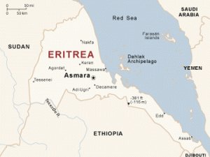
Eritrea Map
Is an ancient name, associated in the past with its Greek form Erythraía and its derived Latin form Erythræa. This name relates to that of the Red Sea, and then called the Erythræan Sea, or “Sinus Erythraeus” in Greek. The Italians created the colony of Eritrea in the 19th century around Asmara, and named it with its current name. After World War II Eritrea was annexed to Ethiopia. In 1991 the Eritreans defeated the Ethiopian government and liberated the country. Eritrea officially celebrated its 1st anniversary of independence on May 24, 1992.